RC30 Aerial Survey Camera Installation in
Navajo Aircraft
Aerial Viewpoint provides vertical format imagery obtained from
Swiss built Leica Heerbrugg RC-30 model aerial survey cameras. These
camera systems are current generation cameras that were first introduced
in the 1990’s. These cameras employ the use of Forward Motion
Compensation (FMC), Global Positioning Systems (GPS) Photo Exposure
Meter (PEM) and Gyro-Stabilized Camera Mount technologies. By utilizing
these specific cameras, our clients receive the highest resolution
and accuracy available from any type of airborne camera or sensor.
In 2006 there are approximately forty five RC-30 cameras in use in
North America including governments and the private sector. Aerial
Viewpoint is one of only two companies in the state of Texas which
operate an RC-30 aerial camera system.
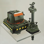
Aerial Survey Camera Basics – An aerial survey
camera produces a 9” x 9” (230 mm x 230mm) image size
and uses aerial film on rolls which measures 9 ½ inches x
500 feet. These camera systems weigh approximately 325 lbs and are
mounted directly over a camera port in the floor of an aircraft.
These cameras are operated at altitudes (in Aerial Viewpoint’s
aircraft) varying from 900’ to 25,000’. Today’s
aerial survey camera is a very precise and extremely complex system
of technologies all engineered into one single system. These cameras
are electro mechanical, they contain optical lens elements, are operated
by multiple computer chips and are linked to GPS satellites.
Forward Motion Compensation – This technology
enables the apparent ground image motion to freeze on the film emulsion
during the exposure cycle. The image quality with respect to sharpness
and resolution is substantially increased by use of this technology.
This has been a standard option with the Leica Heerbrugg cameras
since 1988 when it was first offered on the RC-20 model aerial survey
camera.
Global Positioning Systems – Aerial Viewpoint
utilizes this technology extensively throughout the flight planning
and project acquisition phases of all aerial survey projects. All
of our survey camera systems are coupled to survey grade GPS systems
to insure extremely accurate navigation of flight lines and to precisely
expose pre-determined photo center positions throughout an aerial
survey mission.
United States Geological Survey (USGS) Camera Calibration
Reports – In order to provide aerial mapping photography
services, it is vital to our clients that Aerial Viewpoint’s
aerial survey cameras have an accurate and up-to-date Aerial Mapping
Camera Calibration Report issued by the USGS. These calibration
reports outline precise measurements of the specific characteristics
of each camera system. This report basically outlines the overall
accuracy of the camera lens and camera drive unit. An example of
a few of the categories on a report are, lens distortion (expressed
in microns), calibrated focal length (measured to 1/1,000 of a
millimeter), lens resolving power (known as AWAR) and fiducial
measurements. All of our aerial survey cameras have up to date
USGS calibration reports.
Aerial Film Emulsions – In order to fulfill
a client’s exact requirements, Aerial Viewpoint provides many
different film emulsions. The two most requested film types are panchromatic
(black and white) and natural color, with color infrared being the
least requested. There are many different types of each film emulsion
and all are used for specific needs. As an example, Kodak and AGFA
both produce numerous varieties of panchromatic, color, and color
infrared aerial films; each is to be used for a particular application.
Currently, Aerial Viewpoint utilizes approximately 15 different types
of commercial aerial survey films. Each of these film types require
a specific filter and exposure setting in order for optimum project
success.
|